WHat the Fuck?
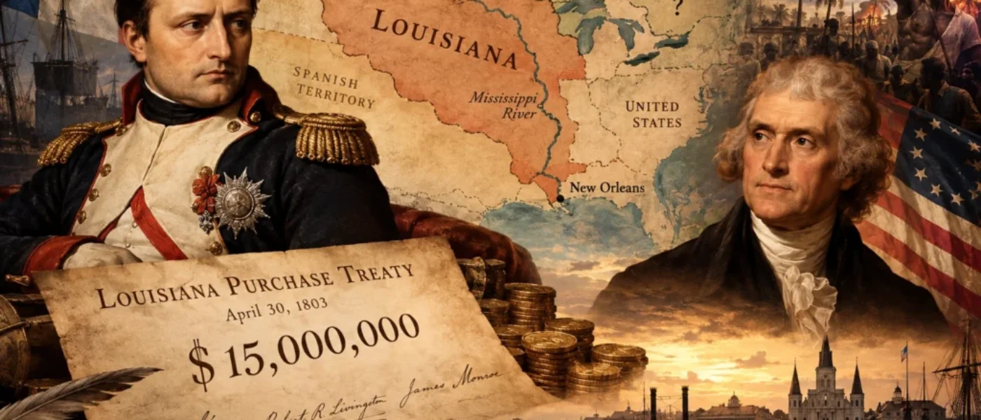
In 1803, Napoleon sold Louisiana to the United States for $15 million, even though neither country knew exactly where the territory ended. The deal doubled the size of the United States, sparked years of border disputes and helped shape the future boundary between Canada and the United States.
WHole Rabbit Hole, Three Sentences
n 1803, Napoleon Bonaparte sold more than two million square kilometres of North America to the United States for $15 million, despite the fact that France, Spain and the Americans could not agree on the territory’s boundaries.
The purchase followed France’s failed attempt to regain control of Saint-Domingue, now Haiti, and led to years of territorial disputes before Britain and the United States agreed in 1818 to establish much of their shared border along the 49th parallel.
The agreement divided Indigenous homelands without the consent of the people living there, helping create the modern boundary between Canada and the United States while leaving Indigenous nations to face the consequences of decisions made by foreign governments.
In 1803, Napoleon Bonaparte sold approximately 828,000 square miles of North America to the United States for $15 million. The transaction doubled the size of the young American republic, gave Thomas Jefferson an enormous political victory, and became one of the most celebrated real estate deals in history.
There was just one rather extraordinary problem.
Nobody could say with any certainty where the property ended.
Not the French government selling it. Not the Americans buying it. Not the Spanish, who had owned it shortly before. The territory had never been comprehensively surveyed by the European powers, and the treaties describing it were spectacularly vague.
Nevertheless, everyone signed the paperwork.
It Started With a Frenchman and a River
In 1682, French explorer René-Robert Cavelier, Sieur de La Salle, travelled down the Mississippi River to the Gulf of Mexico and claimed the Mississippi basin for France. He named it Louisiana in honour of King Louis XIV.
This was an impressive declaration, considering that the enormous territory was already inhabited by Indigenous nations who had established communities, governments, trading networks and territorial relationships long before any Frenchman arrived with a flag.
But European imperial thinking had a remarkable ability to confuse discovering somewhere with owning it.
France’s claim eventually stretched across much of the continental interior, although actual French settlement and administrative control were concentrated in relatively small areas. Much of the land remained unfamiliar to European mapmakers, who filled enormous geographical uncertainties with confident-looking lines and names.
Then France started losing wars.
In 1762, facing defeat in the Seven Years’ War, France secretly transferred Louisiana west of the Mississippi, along with New Orleans, to Spain. The following year, France surrendered much of its remaining North American territory to Britain.
Spain now controlled the crucial southern gateway to the Mississippi River, and for the growing United States, that gateway was becoming extraordinarily important.
American farmers west of the Appalachian Mountains needed to move their produce to market. Roads were primitive, distances enormous, and the Mississippi offered a natural transportation highway to New Orleans, where goods could be transferred to ships bound for international markets.
Whoever controlled New Orleans could therefore exert considerable influence over the economic future of the American interior.
Thomas Jefferson understood this perfectly.
Napoleon Had Other Plans
By 1800, Napoleon Bonaparte was rebuilding French imperial ambitions. Under the secret Treaty of San Ildefonso, Spain agreed to return Louisiana to France. Napoleon imagined restoring a profitable French empire in the Americas, with Louisiana supplying food and resources to France’s Caribbean colonies.
The centrepiece of that plan was Saint-Domingue, the extraordinarily wealthy French sugar colony on the island of Hispaniola, now Haiti.
Saint-Domingue’s wealth had been built on the brutal enslavement of Africans working its plantations. Beginning in 1791, enslaved people rose in revolution, launching a struggle that would eventually destroy French colonial rule and establish independent Haiti.
Napoleon attempted to restore French control in 1802, sending a massive military expedition across the Atlantic. French forces encountered fierce resistance, and yellow fever devastated the expedition.
The campaign became a catastrophe.
Without Saint-Domingue, Napoleon’s plans for Louisiana made considerably less economic sense. France was also facing renewed war with Britain, and defending a vast North American territory across an ocean dominated by British naval power was hardly an attractive prospect.
Suddenly, selling Louisiana looked rather sensible.
The Americans, meanwhile, had been worrying about France controlling New Orleans. Jefferson dispatched James Monroe to join American minister Robert Livingston in Paris, hoping to secure the port and associated territory.
They were authorized to offer up to $10 million.
Napoleon’s representatives offered them the whole of Louisiana for $15 million.
Imagine negotiating to purchase the loading dock behind a warehouse and being offered half the continent instead.
Fifteen Million Dollars. Boundaries to Be Determined.
On April 30, 1803, the Americans signed the Louisiana Purchase Treaty.
The agreement transferred French claims to a territory estimated at 828,000 square miles, approximately 2.14 million square kilometres. At roughly four cents an acre, it was an extraordinary bargain by the standards of imperial land transactions.
There was, however, an astonishing omission.
The treaty contained no precise geographical description of the territory being purchased.
Instead, it referred back to the earlier agreement between France and Spain, describing Louisiana essentially as the territory Spain had held and France had previously possessed.
Unfortunately, those earlier agreements had not properly established its boundaries either.
The French had sold what they claimed to own. The Americans had purchased what France claimed to own. Spain disagreed with some of those claims, and Britain had interests along the northern frontier.
As the Library of Congress explains in its historical examination of the purchase, the negotiators could not provide accurate boundaries because enormous portions of the territory had never been surveyed or mapped by the European governments involved.
Jefferson nevertheless accepted the deal.
He also faced an awkward constitutional question. Jefferson had long argued for a limited interpretation of federal powers, yet the United States Constitution did not explicitly authorize a president to purchase an enormous foreign territory.
Faced with the opportunity to double his country’s size, he chose not to let that particular principle stand in the way.
The treaty was ratified, the transfer proceeded, and the United States acquired an immense territory whose exact dimensions remained open to argument.
It was quite an achievement in international diplomacy: an enormous land purchase accompanied by what amounted to a geographical shrug.
There Was Another Problem. People Already Lived There.
The celebrated bargain becomes considerably less impressive when viewed from the perspective of the people whose homelands were being traded.
Indigenous nations had not authorized France to sell their territories. Nor had they consented to become part of the United States. The purchase transferred European claims of sovereignty, not legitimate ownership of every Indigenous community, farm, hunting ground, waterway and settlement within the vaguely described region.
For Jefferson’s government, however, the acquisition opened the possibility of enormous westward expansion.
The consequences would unfold over generations through American treaties, territorial encroachment, forced removals, warfare and the displacement of Indigenous peoples.
The $15 million paid to France did not purchase Indigenous consent.
It purchased an imperial claim that the United States intended to turn into political and territorial control.
Then Somebody Had to Draw the Border
The northern limits of Louisiana presented another problem. British North America lay to the north, but the precise division between British and American claims across the continental interior remained unsettled.
The United States had acquired French claims without receiving a reliable map showing exactly how far north they extended.
Britain, understandably, did not consider Napoleon’s sale to be a satisfactory method of determining British North America’s southern boundary.
The dispute was further complicated by earlier treaties that had attempted to define borders using geographical information that was incomplete or simply wrong.
For years, the two countries negotiated over territory, waterways, navigation and competing interpretations of where their respective jurisdictions began and ended.
Then, in 1818, American and British negotiators reached an agreement.
The Convention of 1818 established the 49th parallel of north latitude as the boundary from the Lake of the Woods westward to the Rocky Mountains, with a connecting line from the lake to that parallel.
It was a remarkable solution to a remarkably complicated geographical problem.
Rather than attempting to reconstruct every vague French, Spanish and British territorial claim, the two governments agreed upon a line of latitude.
A line that could be surveyed.
A line that could appear on maps.
A line that would become a defining feature of the modern Canada–United States border.
The agreement did not establish the entire international boundary. The region farther west remained disputed, and other sections of the border would require additional treaties. But across the continental interior, the 1818 convention established a boundary that largely survives today.
And That Is Where Canada Enters the Story
Here is the part of the Louisiana Purchase that tends to disappear from the familiar American version of events.
When Napoleon sold Louisiana in 1803, Canada did not yet exist as a Confederation. The lands north of the eventual border were part of British North America and the territories of Indigenous nations whose relationships with European empires were far more complicated than the maps suggested.
Fifteen years after the purchase, Britain and the United States agreed to divide a substantial portion of the continent along the 49th parallel.
That decision helped determine which lands would eventually lie within Canada and which would form part of the United States.
It also divided Indigenous territories and communities whose histories had never followed a European line of latitude.
The international border was not simply the natural edge of Napoleon’s Louisiana. It was the product of subsequent diplomacy between governments seeking to settle competing territorial claims.
And that distinction matters.
Napoleon did not sell Alberta to the Americans. Nor did the Louisiana Purchase establish the modern Canadian border by itself. What it did was dramatically expand American territorial claims and help create the diplomatic circumstances in which the northern boundary had to be settled.
The United States celebrates the Louisiana Purchase as one of the greatest bargains in its history. France obtained money for territory Napoleon could scarcely defend. Britain negotiated a continental boundary without surrendering all its northern interests.
And Indigenous peoples watched foreign governments negotiate over territories they had never agreed to sell.
Three imperial powers, one expanding republic, millions of acres, and a collection of treaties that could not properly explain where the property began or ended.
The astonishing thing is not that it took another fifteen years to establish a substantial portion of the northern boundary.
It is that anyone thought the original transaction was sufficiently clear to sign in the first place.
Psst… The Story Doesn’t End With Napoleon
The Louisiana Purchase was hardly the only extraordinary example of European powers treating North America as transferable property.
In 1670, an English king had granted a trading company sweeping commercial and territorial rights over an enormous region of northern North America. Two centuries later, the company would surrender those claims as Canada expanded westward.
And the company would receive £300,000 as part of the arrangement.
Next: The King Who Gave Half a Continent to a Department Store.
The Fuckwhittery Footnote
The events in this story are real. The treaties, dates, financial arrangements and territorial disputes are documented in historical records. There is plenty more to discover, particularly about the Haitian Revolution, the Indigenous nations affected by American expansion, and the extraordinary uncertainty surrounding the boundaries of Louisiana.
Most of us learned that Napoleon sold Louisiana to Thomas Jefferson for $15 million. Far fewer of us learned that the territory’s boundaries were so poorly defined that governments spent years arguing about what had actually been purchased.
Because history becomes considerably more interesting when we stop memorizing the dates and start examining the astonishing decisions people made.
Explore the Louisiana Purchase, its disputed boundaries and the Canadian connection in ChatGPT
Psst… The Story Doesn’t End With Napoleon
The Louisiana Purchase was not the only time European rulers treated North American land as property they could give away or sell. In 1670, King Charles II of England granted the Hudson’s Bay Company sweeping trading and governing powers across a vast region already inhabited by Indigenous nations.
Nearly two centuries later, Canada negotiated to acquire the company’s territorial claims. The Hudson’s Bay Company received £300,000 and kept valuable land interests, while the people living on those lands had no equal voice in the agreement.
The next story follows the royal charter, the fur trade and the company that eventually became a Canadian department store.
Keep Following the WHole Rabbit Hole
The next chapter moves from Napoleon’s disputed borders to the Hudson’s Bay Company’s royal charter and the transfer of Rupert’s Land to Canada.
The FuckWHittery Footnote
The events in this story are documented in historical records. The 1803 purchase, its disputed boundaries, the Haitian Revolution and the border agreements that followed reveal how much was left unsettled by the sale.
Many of us learned that Napoleon sold Louisiana to the United States for $15 million. Far fewer learned that the territory’s boundaries were so unclear that governments spent years arguing over what had been purchased. Indigenous nations, whose homelands crossed those borders, had no say in the transaction.
History becomes more revealing when we look beyond the dates and examine the decisions, the people who made them and those who lived with the consequences.
Still Wondering WHat the Fuck?
The Louisiana Purchase left major questions about borders, land ownership and the rights of Indigenous nations. Explore the original treaty, the Haitian Revolution’s effect on Napoleon’s plans, and the 1818 agreement that helped establish the Canada–U.S. border. Follow the historical records to see what the governments agreed to and what remained unresolved.
Take This Rabbit Hole to ChatGPT →The WHole Paper Trail
The Louisiana Purchase, the uncertain borders and the later agreements are documented in historical records. These sources show what was signed, what remained disputed and how the border between Canada and the United States took shape.
U.S. National Archives — Louisiana Purchase Treaty (1803) →
The original treaty setting out the agreement between France and the United States in 1803.
Library of Congress — A Question of Boundaries →
Explains why the boundaries of the purchased territory were unclear and became the subject of later disputes.
U.S. Office of the Historian — Louisiana Purchase →
Explores Napoleon’s plans, the conflict in Saint-Domingue and the negotiations with the United States.
U.S. Office of the Historian — Rush-Bagot Agreement and Convention of 1818 →
Explains the 1818 border agreement between Britain and the United States and the parts of the boundary it addressed.